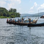
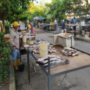
Forests and fish are inextricably linked through freshwater systems and have a direct impact on the well-being of all. These freshwater ecosystems, essential for human health and agriculture while hosting exceptional rates of biodiversity, are at risk from land-use changes and land degradation.
‘Resilient rivers: counting fish from forests for food security’ is a joint initiative between the Food and Agriculture Organization of the United Nations' Forestry Division and Fisheries and Aquaculture Division that seeks to transform the management of these resources through multidisciplinary collaboration. The project combines on the ground work with stakeholders and remote sensing tools to improve data collection, build capacity for sustainable forest and watershed management, and ensure food and water security.
With watershed-based management and the UN Decade on Ecosystem Restoration as overarching frameworks, this project brings together existing information such as fisheries data, forest cover data, and stakeholder surveys to enable multidisciplinary and innovative management and monitoring solutions which empower stakeholders and foster collaboration. Learn more here.
CIFOR-ICRAF scientists have been researching the interactions between forests and fish in the tropics for several years. This project fostered a collaboration between CIFOR, WorldFish and FAO to raise the global profile of integrated management and watershed-based approaches. You can find out more about the successes of this collaboration in CIFOR's blog post.
Resilient Rivers E-learning: Watershed-based management of forests, freshwater, and inland fisheries
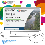
Launched at the UN 2023 Water Conference, this e-learning focuses on freshwater systems and aims to inspire stakeholders to work across disciplines. It guides learners to understand, monitor and manage watersheds as integrated systems, looking at watershed function and focusing on opportunities for coordinated monitoring and management of forests, freshwater and fisheries. Available in English and Spanish.
SEPAL's Resilient rivers and basins app is a new freely-accessible tool which was developed by using the team's process to track forest cover change using satellite imagery. The tool describes forest cover and forest cover change from a watershed perspective by calculating statistics across sub watersheds over time. You can find out more here.

Project work in the upper Kafue River in Zambia offers a local perspective and a convincing case study for understanding and managing on-the-ground conditions. This map poster shows an integrated watershed assessment which links forest cover change, fisheries data analysis, community knowledge, and expected changes in climate and human population.
Photo credits: Fundación Humedales