Project results and activities in Sri Lanka
Sri Lanka is an island country in the Indian Ocean with a land area of 65 610 km2 and a population of 21.6 million. It has a network of approximately 103 principal rivers and tributaries, most of which originate in the central and southern parts of the country.
There are three climatic zones in Sri Lanka: the dry zone (annual rainfall less than 1 750 mm), the intermediate zone (annual rainfall 1 750–2 500 mm) and the wet zone (annual rainfall 2 500–4 500 mm). The only source of water is direct rainfall. The biggest user of water is agriculture.
Agriculture contributed around eight percent to national GDP in 2020. Rice is the most important crop, producing 4.1 million tonnes in 2019–2020, enough to feed the entire population of the country. Paddy is grown all over the country, mainly during two monsoon seasons, the Maha season from September to March and the Yala season from April to September. Rice contributes to 1.8 percent of country’s GDP and 1.8 million families are engaged in its production. About 983 550 hectares are under paddy, 43 percent of all agriculture lands.
According to the Climate Risk Index 2021, Sri Lanka is the thirtieth most climate-vulnerable country in the world. The country is highly susceptible to extreme weather events such as prolonged droughts.
Due to population growth, economic growth and industry-led deterioration of water quality, the competition for water and water scarcity have increased in recent years.
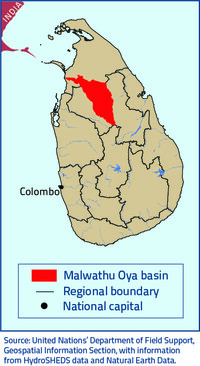
Project area: Malwathu Oya southern catchment
The Malwathu Oya basin is the second largest river basin in Sri Lanka (3 284 km2) and one of the major agricultural areas in the country.
The KnoWat project area, the Malwathu Oya’s southern catchment, extends over 77 950 hectares. The population in the area has been estimated at 204 775. Agriculture, and especially rice farming, is the predominant household livelihood.
The cultivation of rice has been practiced for thousands of years in this dry part of northern Sri Lanka where ancient civilizations flourished, partly due to the irrigation systems. Today, there are a large number of ancient and modern tanks and reservoirs in the basin that have been built for irrigation and domestic water supply.
Results
Developed by the Food and Agriculture Organization of the United Nations (FAO), the Water Productivity through Open-access of Remotely-sensed derived data (WaPOR) tool monitors water productivity in near-real time through remote sensing, identifies water productivity gaps and proposes solutions to address these gaps. The KnoWat project created a geospatial database – based on WaPOR – that covers all of Sri Lanka and, at a higher resolution, the Malwathu river basin. Sri Lanka the first Asian country to have a WaPOR database. A comprehensive water resources assessment of Sri Lanka and Malwathu river basin were carried out to acquire key data and information on water accounting, governance and water productivity.
The KnoWat project trained technical staff of key government institutions at national, basin and local levels to use data for better water management, and identified different development pathways to agricultural development in the river basin. The project also worked to raise awareness of national stakeholders from government, civil society, private sector and the media of issues relating to water scarcity, water access and agricultural water productivity, and the links between water tenure and climate change.

