Publications
2019
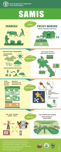
The poster describes the project’s concept include: users, objectives, methods and results. This poster explains how the FAO GEF project communicates information generated from the different stakeholders at national, provincial, and local levels
2019
The leaflet present the activities of the first component of the project “Strengthening Agro-climatic Monitoring and Information Systems (SAMIS) to improve adaptation to climate change and food security in Lao PDR”. The component, implemented in strict collaboration with the Department of Meteorology and Hydrology (DMH), Ministry of Natural Resources and Environment, is titled “Strengthening agro-climatic monitoring, analysis, communication and use of data and information for decision making in agriculture and food security”. The activities includes the installment of agro-meteorological stations, the setup of a Laboratory for agro-meteorological analysis and instrument calibration, the implementation of the Laos Climate Services in Agriculture (LaCSA) system for modelling and distribution of climate services to farmers, and the facilitation of a process to ensure national Standard Operation Procedure are followed.
2019
The leaflet present the activities of the second component of the project “Strengthening Agro-climatic Monitoring and Information Systems (SAMIS) to improve adaptation to climate change and food security in Lao PDR”. The component, implemented in strict collaboration with the Department of Agriculture Land Management (DALaM), Ministry of Agriculture and Forestry (MAF), is titled “strengthening institutional and technical capacity for monitoring and analysis of agricultural production systems and development of Land Resources Information Management System (LRIMS) and agro-ecological zoning (AEZ)”. This leaflet explain how the FAO GEF project will address monitoring, observation, analysis, data storage, and development of value-added information products, promote sharing, and better inform agricultural decision-making. Also, it will produce an information systems and develop the Agro-Ecological Zone (AEZ) assessment will benefit multiple sectors and decision makers and will be developed in close collaboration with other development partners working on similar areas.
2019
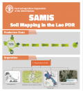
Soil mapping using machine learning in Lao PDRThe GIS unit of the Department of Agricultural Land Management (DALaM) of the Ministry of Agriculture and Forest of Lao PDR is develop a new national level soil map. Working through the project “Strengthening Agro-climatic Monitoring and Information Systems (SAMIS) to improve adaptation to climate change and food security in Lao PDR” funded by GEF and implemented by FAO, the activity is inserted in a broader exercise focusing on developing a national level decision making schemes for long term land planning.The soil map based on the World Soil Classification Systems is ongoing. The samples were finalized in the provinces of Phongsaly, Bokeo, Luangnamtha, Xayabouly, Oudomxay, Luangprabang, Houaphanh, Champasack, Salavan, Xekong, and Attapue.All soil profiles records name of the profile, soil depth, date, land use type, complete soil description, GPS coordinates, photos of the soil profiles, and description of the land use situation. The laboratory analysis is ongoing. So far, half of the soil samples were analyzed and the map will be ready the end of 2019.
2019
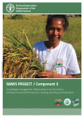
The leaflet present the activities of the third component of the project “Strengthening Agro-climatic Monitoring and Information Systems (SAMIS) to improve adaptation to climate change and food security in Lao PDR”. The component, implemented in strict collaboration with the Ministry of Natural Resources and Environment (MONRE); Ministry of Agriculture and Forestry (MAF); and CAWA project, is titled “Knowledge management, dissemination of information, lessons learned for local application, planning and evaluation”. This leaflet explain how the FAO GEF project will communicate information generated from Components 1 and 2 to the different stakeholders at national, provincial, and local levels. This provides knowledge management and dissemination of information and lessons learned for planning, monitoring and evaluation. At local level, the weather, climate, land resources, and climate-change impact information will be disseminated to farmer groups through established farmer field schools (FFS)
