Innovations and digital technology applications for One Health
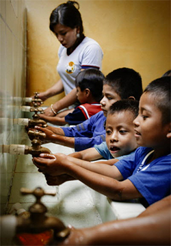
Pathogens enter the environment through several pathways before infecting food, but usually follow an oral-fecal route and water is an important vehicle for those contaminations. The sewage entering the environment through agricultural practices e.g., irrigation with partially treated or untreated wastewater, excreta and greywater might contain more pathogenic microorganisms than other surface or underground water sources used for irrigation or aquaculture. Considering the numerous pathways of water-related foodborne microbiological contamination, constraints in food safety efforts could limit existing food safety surveillance systems’ efficiency.
A better understanding of how pathogens move from agricultural areas to the environment through water is important for developing guidance towards cost-effective management of food safety and supporting evidence-based policymaking. Strong land and water quality management guidelines and policy-frameworks are needed. FAO promotes the advancement and utilization of innovative scientific tools such as whole genome sequencing (WGS) and metagenomics techniques to improve environmental microbiological contamination monitoring and surveillance of pre-harvest factors, pathogens source-tracking using genomics and hydrological modelling coupled with other risk prevention measures.
Additionally, FAO supports research on WGS and food safety, such as Global Microbial Identifier, PulseNet International and GenomeTrakr, and support developing countries to share information, knowledge and experience in using WGS for water quality and food safety management.
The data can be accessed by researchers and public health officials for real time comparison and analysis that can speed foodborne illness outbreak investigations and reduce foodborne illnesses and deaths from water. Prevention is better than cure, and publicly shared data is key to shifting the focus from responding to foodborne diseases through water, to preventing contamination at source.
Agriculture is a highly demanding energy sector. Electrical and mechanical power is required in agriculture for a number of activities, including land preparation, seeding, irrigation, and harvesting, amongst others. Furthermore, water pumping and distribution through irrigation systems demand the availability of consistent and reliable energy resources. The water-energy nexus, in the agricultural sector, is instrumental, and any increase in demand in any one sector has flow-on effects on the other one.
Urban environments are equally confronted with the high and ever-increasing energy demand to supply water and ensure a healthy and widespread provision of resources for domestic and industrial uses. The implementation of solar-powered pumping systems can also increase access to sustainable and safe water resources for both domestic and production purpose.
- Somalia Flood 01.04.2020 - 15.04.2020
- Somalia Flood 16.04.2020 - 01.05.2020
The data collected from satellite imagery, big data and citizen science (crowd-sourcing, on-the-ground data), information and analytics for understanding immediate conditions of crop maturation and harvesting status (i.e., delays could results in production loss and impact on crop quality), situation of the food supply chains, water resource availability and impact the next planting season, etc., are critically important in the context of COVID for coordinating short-, medium-, and long-term response plans.
Tools for Policy Support
FAO Land and Water is playing a key role by assessing how global health is affecting the food and agriculture sector with an array of tools for supporting policy analyses and for assessing impacts of COVID-19 on food and agriculture, value chains, food prices, and food security across the globe. Examples of databases and tools for accessing data and remote sensed, near real-time information include land cover mapping tool , Global Agro-ecological zoning (GAEZ) tool for crop productivity and sustainable land management, Water Productivity through Open access of Remotely sensed information (WaPOR), Land Resources Information and Management Systems (LRIMS) to create a secure, reliable, efficient, accountable and equitable system of management of land resources related to agriculture and a number of E-Learning and Information, Communication Technology (ICTs) tools.
COVID response plan policies through geospatial data, digital technologies, open data tools participatory approaches and citizen science include:
- Geographic locations for identifying first-respondent interventions such as handwashing stations can be prioritized by geospatial analysis, satellite imagery, and open street maps to assess the most vulnerable populations by considering population density, infrastructure, access to water, city-region food flows, etc. The data can identify the most vulnerable areas and urge countries to meet the immediate food needs for vulnerable populations in urban or in remote areas.
- Supply chain factors and policy priorities via geospatial data and remote-sensed information on important factors such as food production, planning and monitoring planting and harvesting seasons, water productivity, production losses, impacts on crop quality and disruptions in food supply chain, as well as providing solutions by analysing the agriculture opportunities in urban, peri-urban and rural areas.
- Hot-spot analyses to highlight where the most vulnerable population to be affected;
- Prevent food loss and waste via digital technology information to locate the cold storage facilities and transfer payments.
- Social inclusion policies via the mapping of vulnerable and indigenous populations and their support-based systems such as transportation disruption, water and food shortage conditions, andmore.
- Sustainability policies’ support through trend analysis on cropping areas, crop type, and water productivity over time for project interventions and applications of fiscal policies such as subsidies and their impact on system vulnerability, agricultural impacts’ practices on biophysical and socioeconomic circumstances.
- Capacity development and human resources and jobs policies can be supported through the combination of FAO’s land and water information and communication technologies (ICTs) and geospatial development tools trainings to enable farmers to water resource managers in making faster and better decisions on water management. ICTs are critical when public health regulations brought on by COVID-19 are restricting movements and gathers, including capacity development events and advisory services to farmers and government institutional partners alike.
ICT Platforms by FAO Land and Water
FAO is supporting capacity development programs that combine information and communication technologies (ICTs) and geospatial information in user-friendly phone applications to help making better and faster decisions on water management. ICTs are even more critical at times when public health regulations brought about by Covid-19 are restricting movements and gatherings, including capacity development events and advisory services to farmers. Using phone applications, text and video messages, we continue supporting farmers and stakeholders at different scales accessing the information they need and when they need it. Read more about it in WaPOR events and capacity development reports, including materials used for a workshop held in April 2020 on using ICTs for water productivity in Lebanon.
E-Learning in FAO Building Forward Better Initiative - Strengthening natural resources management capacities to revitalize agriculture in fragile contexts with course modules on: water productivity, land resource planning, water resource efficiency, hydro-economic modelling, integrated drought management, water harvesting and agroforestry, investments, renewable energy in irrigation, asset management, early warning systems, climate change and mitigation/adaptation strategies, agriculture indices for performance assessments, and monitoring and evaluation.
For more info please contact: