PyWaPOR

The WaPOR database contains data on, among others, water-productivity, actual evapotranspiration, and biomass production at three different spatial resolutions. The coarsest datasets are available globally, while the more detailed datasets are limited to specific regions. PyWaPOR allows users to generate these detailed datasets for areas not covered by the WaPOR database and more.
To calculate high-resolution data, input data needs to be downloaded, pre-processed, and finally ingested into a model (called ETLook). PyWaPOR is a set of open-source scripts (written in Python, together called a module) that helps users do exactly that. Given an area-of-interest and period, pyWaPOR can automatically download and prepare the required inputs datasets for the selected region and period, configure the ETLook parameters and run the actual model. It thus allows governments, institutions, and individuals to expand the geographical coverage of the WaPOR database.
In addition, pyWaPOR allows users to experiment with alternative data pre-processing, model configurations and input datasets and to export intermediate variables that are calculated by the model but are not part of the WaPOR database.
To summarize, pyWaPOR can:
- Automatically download remote-sensing data from a range of sources, like Landsat 5-9, Sentinel 2-3, MODIS, VIIRS and many others.
- Pre-process these datasets, making sure they all share the same projection and resolution, invalid or low-quality pixels are masked, gaps are filled, and outliers are smoothed.
- Calculate water productivity, actual evapotranspiration, biomass production and many other variables at a spatial resolution of up to 20 meters at a daily temporal resolution.
- Export results in netCDF files that can be easily opened in any GIS software of your choice for further analysis.
👤👤 PyWaPOR users
pyWaPOR is a powerful tool for analysing water consumption and productivity in agriculture. It does require some level of technical skill and knowledge to use effectively. Users should have a basic understanding of remote sensing, geospatial analysis, and programming to be able to do so.
Fortunately, there are resources available to help users build the necessary skills to use pyWaPOR. The pyWaPOR documentation provides detailed instructions on how to install and use the package. Additionally, IHE Delft's Open Course on Water Productivity and Water Accounting using WaPOR, contains a section on WaPOR spatial data analysis using Python, which could be a suitable resource to get started. Finally, as part of the WaPOR project, partner countries can include pyWaPOR training as part of their capacity-building plan if they wish to develop high resolution datasets outside of their default high resolution areas.
Overall, with the right training and support, it can be a valuable tool for researchers, practitioners, governments, and NGOs interested in applications of the data.
PyWaPOR use case in Jordan
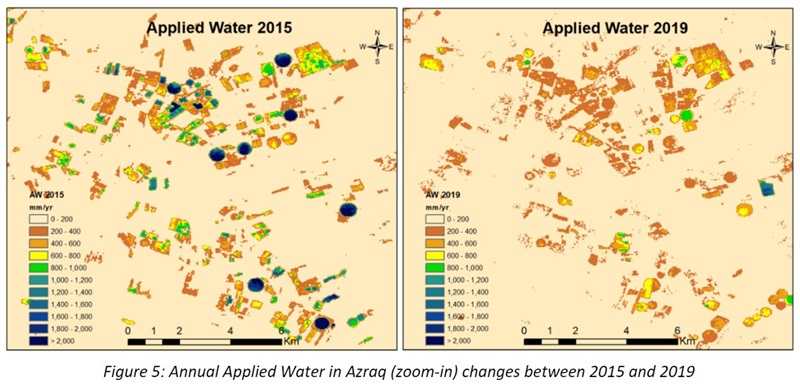
For instance, an early version of pyWaPOR was used in Jordan in 2020 to create a 30-meter dataset that was used to calculate the amount of groundwater that was being withdrawn for agricultural use.
The Jordanian government has made better management of the country's water resources a top goal because Jordan is a particularly water-stressed country. They want to put an end to the practice of illegal groundwater abstraction since it has been causing important aquifers to deplete.
WaPOR data has been investigated as a potential tool to aid authorities in this work, and the data has indeed demonstrated a strong potential throughout the exercise, although further research is required to develop a more precise method.
Learn more by following this map story that summarises the work done in Azraq, Jordan.

