Tools and methodologies were selected based on the ability to carry out multi-variable assessments at various scales within the given (PPG) timeframe and in close alignment with the LDN conceptual framework/CF (Module A). The assessment results were used for project targeting (child projects) as well as for the establishment of a LDN decision support system during the child projects’ implementation with the support of the Regional Exchange Mechanism.
The baseline assessments were conducted at different levels and timelines using various participatory and inclusive tools and data collection formats as follows:
- Remote sensing sites using Collect Earth to determine types of land use, land use change, land cover, and disturbances
- Multi-stakeholder group (MSG) discussions (1-2 days) at regional/district/site level for:
- Rapid participatory land degradation (LD) assessment to determine the main types, extent, degree, rate and causes of land degradation; main groups of SLM/SFM practices implemented
- Participatory stakeholder analysis (note: same exercise was conducted for the national level during PPG inception workshop)
- Policy, institutional and capacity needs analysis
- Rapid sustainable value chain mapping, prioritization and analysis
- Indigenous Peoples and the Free, Prior and Informed Consent assessment (FPIC) assessments (when relevant)
- Rapid participatory land degradation (LD) assessment to determine the main types, extent, degree, rate and causes of land degradation; main groups of SLM/SFM practices implemented
- Household surveys using the Self-evaluation and Holistic Assessment of climate Resilience for farmers and Pastoralists (SHARP) tool to assess resilience of rural households
The combination of the different tools and analyses allowed the application of resilience thinking (i.e., identification of risks, exposure and vulnerability levels) at different scales, comprising the adaptative and transformational change component.

Moreover, the integrated approach emphasize the need to engage different stakeholder at different levels and sectors (i.e., through MSG and household surveys) to assess the current state of their productive systems and their communities, and to identify priority variables for changing to a desired state of the system. Gender analysis was also included at multiple levels (excluding remote sensing) to account for differences in needs of men and women.
Seeing from Above
Learn More:
Earth observations and remote sensing products are becoming more and more abundant, accurate, and easy to access. They offer an excellent opportunity to quickly assess what is occurring in the landscape.
FAO has been in the forefront of development of tools for forest and land monitoring in support of its member countries. The Open Foris Initiative, support by multiple FAO and non-FAO projects, hosts state of the art tools and methodologies for data collection, data processing, data analsyis, and visualization.
The DSL-IP applied Open Foris Collect Earth and EarthMap to gather data and information in its ILAM application. Collect Earth focused on sampling approaches for land representation (IPCC 2006), leveraging on local expert knowledge and previous initiatives, like the Africa Open Data for Environment, Agriculture and Land (DEAL) and Africa’s Great Green Wall. EarthMap focused on the analsyis of existing remote sensing products that are relevant for the characterization of the landscape.
EarthMap is developed by FAO and build on Google Earth Engine. It is a powerful platform that combines a user-friendly interface with powerful statistics. Its direct links to Google Earth Engine ensures a vast array of layers and images are constantly being updated, expanded, and improved. Google and FAO began their partnership in 2015, signing an agreement on the sidelines of the Paris Agreement.
In the application of ILAM during project design, trends.earth was used for the mapping of land degradation using SDG's 15.3.1 approach.

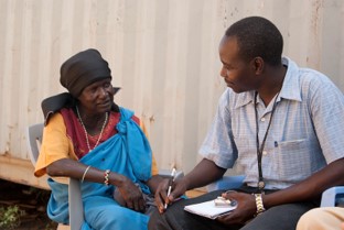
In the DSL-IP, ILAM's stakeholder consultation component is disverse in scope and scale. Tailored multi-stakeholder group discussions (MSGs) were designed and facilitated by LDN/SLM specialists, Policy, Institution and Capacity assessment Experts, as well as the Value Chain (VC) Consultants with the support of the Enumerators, the national FAO office representatives, and relevant government focal points. It builds on yeats of FAO's expertise in capacity development and facilitation of multi-stakeholder processes.
Key clear goals were set for the MSGs:
- Validate and gather additional baseline data/information from the targeted landscapes
- To stimulate interaction between different stakeholders, raise awareness, reach common understanding about the intended project, as well as the current environment within which the projects will be implemented.
- Galvanize ownership and commitment across all stakeholders
- To identify key on-the-ground interventions to be integrated into the project and sharpen project targeting
- To select value chains the project will focus on and gather data for value chain assessment and feasibility of value chain development

Hearing the land users
Learn More:
Household surveys are an important tool to gather valuable data directly from the land users themselves. The DSL IP worked closely Plant Production and Protection Division to develop a customized version of the Self-evaluation and Holistic Assessment of climate Resilience of farmers and Pastoralists (SHARP) survey, which was deployed in six Miombo/Mopane countries. The survey was complemented with questions on the use of trees and forest products by the land users, as well the impacts of land degradation.
From the survey data, we learned that 85% of the respondents had trees in their farmland. Trees in and outside forests were the main source of energy (woodfuel), and were also used for construction, timber production, animal feed and medicines. Across the different DSL-IP landscapes, land degradation was mentioned by the land users as a key factor leading to reduced productivity.
Currently, the DSL-IP ILAM Household Survey is finalized and being applied in country projects in Southern Africa. The survey was custumized to include key elements to enable monitoring and evaluation and learning more about the characteristics of the project landscape communities.
Integrated Landscape Assessment Methodology (ILAM)
The DSL-IP continuously work to integrate and leverage on the data collected through ILAM, ensuring partners have the adequate data to better manage project implementation, monitoring, and evaluation efforts. ILAM is not static, and its development and refinement is a key component of the DSL-IP Communities of Practice.