Efficient use of water in agriculture: water productivity using satellite data
The KnoWat project created a geospatial database based on remote sensing data gathered through the Food and Agriculture Organization of the United Nation’s WaPOR (WAter Productivity through Open-access of Remotely-sensed derived data) tool.
The database was used to assess agricultural water consumption and water productivity by interpreting satellite images in the Senegal River Basin. It includes eight years of data (2015–2022) covering the entire Senegal River Basin (426 139 km2), including parts of Guinea, Mali, Mauritania and Senegal – at a 100 metre resolution, and the Ross Bethio section of the Senegal River Delta (611 km2) at a 30 metre resolution. Data on evapotranspiration, biomass production and land cover for these areas are freely available on FAO’s WaPOR portal for the period 2015-2022.
To calibrate land cover data to 30 metres, the project conducted a land cover assessment in the pilot area during three seasons: winter season 2020/2021, cold dry season and hot dry season 2021.
Water productivity assessment
- FAO. 2022. Water Productivity through Open-access of Remotely sensed derived data. In: FAO. Cited 13 December 2022. https://wapor.apps.fao.org/

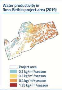
To demonstrate the usefulness of the WaPOR portal in areas of scarce water resources, the KnoWat project carried out a crop water productivity assessment for rice cultivation in the Ross Bethio area during the winter season (July–November) and hot dry seasons (February–July) 2015–2021. The assessment calculated crop yield, water productivity and irrigation performance indicators such as water uniformity and adequacy.
The assessment showed that yields in the hot dry season are higher than in the winter months. The yields reported by the WaPOR-based model are generally lower than those reported by the Société d'Aménagement et d'Exploitation des terres du Delta et de la Vallée du fleuve Sénégal (SAED), which manages the irrigation systems in the pilot area.
Water productivity shows a steep gradient from upstream to downstream fields, particularly in the hot season. This shows that there is considerable potential to improve the performance of irrigation, particularly towards the tail end of the system.
Capacity building to ensure the sustainability of the project's achievements
The KnoWat project trained thirty experts from partner institutions in Senegal to interpret WaPOR data and to use the tool for water resources assessment and system-level applications, including water productivity analysis.
In May 2021, a virtual training session for 15 technical staff of partner institutions was held on the WaPOR and PROGRES databases.
The project also supported the organization of a major capacity building programme from 21 to 24 September 2021 in Saly, Senegal, as part of the joint project "Improving Land and Water Productivity in the Sudano-Sahelian Belt," funded by FAO. The session assisted about twenty national experts to strengthen their capacities in the practical use of the WaPOR tool.
Expanding the application of remote sensing techniques
Thanks to the KnoWat project, key actors in Senegal now fully recognize the importance of the WaPOR tool for their work, particularly for providing useful evidence for decision-making.
Through the KnoWat project, FAO has signed letters of agreement with public organizations such as SAED and the Directorate of Management and Planning of Water Resources (DGPRE), as well as with civil society organizations, such as the National Council for Consultation and Cooperation of Rural People (CNCR), in order to foster synergy of action.
In the future, for example, WaPOR can be used in water balance studies in the Senegal River Basin and elsewhere, to support water accounting, where available data are limited. This will further inform rational water resources planning and management.